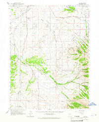
1962 Map of Lee
USGS Topo · Published 1966About this map
Te-Moak Indian Reservation lands dominate the center of this Elko County landscape, where the South Fork Humboldt River carves through the terrain near Twin Bridges. The geography is defined by a sophisticated system of water management essential for high-desert ranching and agriculture, evidenced by the Hankins Bellinger Ditch, Swamp Ditch, and the Dry Farm Reservoir. The settlement of Lee sits at the base of the Ruby Mountains, serving as a gateway to the Humboldt National Forest.
Find a feature on this map
59 named features on this map. Tap any name to fly to it.
Don’t see what you’re looking for? This feature index may not catch every label — zoom into the map to look around manually.
Map Details
Editions of this 1962 Lee Map
This is the sole edition of this map. No revisions or reprints were ever made.
Other maps of this area
1934 · Jiggs
USGS Topo · 1:125,000
1935 · Halleck
USGS Topo · 1:125,000
1937 · Jiggs
USGS Topo · 1:125,000
1952 · Dixie Flats
USGS Topo · 1:62,500
1955 · Elko
USGS Topo · 1:250,000
1956 · Robinson Mtn
USGS Topo · 1:62,500
1957 · Elko West
USGS Topo · 1:24,000
1957 · Elko East
USGS Topo · 1:24,000
1958 · Elko
USGS Topo · 1:250,000
1959 · Jiggs
USGS Topo · 1:62,500