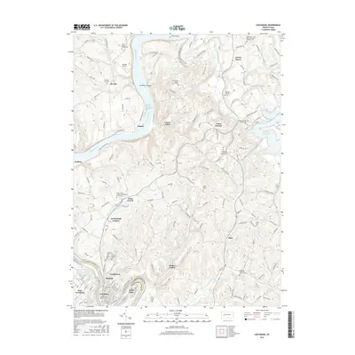
2016 Map of Leechburg
USGS Topo · Published 2016About this map
The Allegheny River and Kiskiminetas River converge at the heart of this landscape, defining the industrial and residential boundaries of Armstrong Co and Westmoreland Co. The rugged river valley is punctuated by several small communities, including the borough of Leechburg and neighboring Hyde Park, where the local economy was historically tied to the waterways and the Allegheny Valley RR. Further north, the river winds past Nicholson Island and Ross Island, while the eastern portion of the map is dominated by the waters of Crooked Cr Lake. Genealogists will find a high density of burial grounds, from the Ukrainian Catholic Cem to the isolated Small Family Cem. These sites, along with landmarks like Lookabough Corners and Forks Church, represent the long-standing social and religious hubs that anchored rural life outside the river-bound town centers.
Find a feature on this map
169 named features on this map. Tap any name to fly to it.
Don’t see what you’re looking for? This feature index may not catch every label — zoom into the map to look around manually.
Map Details
Editions of this 2016 Leechburg Map
This is the sole edition of this map. No revisions or reprints were ever made.
Other maps of this area

1900 · Kittanning
USGS Topo · 1:62,500

1901 · Rural Valley
USGS Topo · 1:62,500

1902 · Kittanning
USGS Topo · 1:62,500

1902 · Elders Ridge
USGS Topo · 1:62,500

1903 · Rural Valley
USGS Topo · 1:62,500

1904 · Elders Ridge
USGS Topo · 1:62,500

1907 · Freeport
USGS Topo · 1:62,500

1909 · Freeport
USGS Topo · 1:62,500

1953 · Pittsburgh
USGS Topo · 1:250,000

1953 · New Kensington East
USGS Topo · 1:24,000