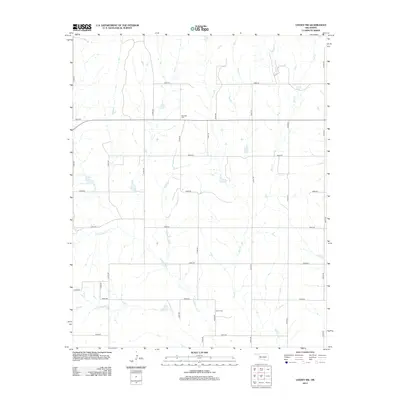
2012 Map of Leedey SW
USGS Topo · Published 2012About this map
Red Star Cem and Dewey Cem sit among the section lines of western Oklahoma, marking the lasting legacy of rural communities in this prairie landscape. The terrain is defined by the drainage networks of Quartermaster Cr and Hay Cr, which carve subtle valleys through a grid of local roads. This area reflects a late 20th-century agricultural pattern where large-scale farming and ranching are supported by a precise network of routes like e0810 RD and n1980 RD. The sparse placement of these cemeteries amidst the winding course of Cyclone Cr provides a primary point of reference for genealogists tracking family plots in Custer County.
Find a feature on this map
25 named features on this map. Tap any name to fly to it.
Don’t see what you’re looking for? This feature index may not catch every label — zoom into the map to look around manually.
Map Details
Editions of this 2012 Leedey SW Map
This is the sole edition of this map. No revisions or reprints were ever made.
Other maps of this area

1955 · Clinton
USGS Topo · 1:250,000

1957 · Clinton
USGS Topo · 1:250,000

1960 · Cheyenne
USGS Topo · 1:62,500

1960 · Hammon
USGS Topo · 1:62,500

1961 · Leedey
USGS Topo · 1:62,500

1965 · Roll NE
USGS Topo · 1:24,000

1966 · Roll SE
USGS Topo · 1:24,000

1984 · Foss Reservoir
USGS Topo · 1:100,000
1987 · Leedey SW
USGS Topo · 1:24,000
1987 · Flying Creek
USGS Topo · 1:24,000