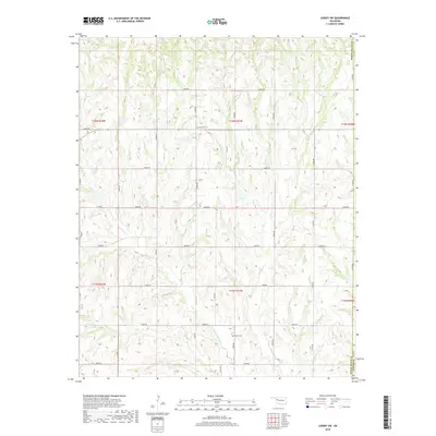
2018 Map of Leedey SW
USGS Topo · Published 2018About this map
Quartermaster Creek and its tributaries define the undulating topography of the Oklahoma plains along the border of Roger Mills and Custer counties. This 2018 survey documents a landscape dominated by a methodical grid of rural sections and roads such as E0840 Road and E0860 Road, which serve the agricultural land between the creek beds. Cultural and genealogical history is preserved in small, localized sites like Red Star Cemetery and Dewey Cemetery, which stand as quiet landmarks within the sprawling section lines. The drainage patterns of Cyclone Creek and Hay Creek illustrate the natural erosion of the high plains, providing a detailed look at the watercourses that have historically dictated the placement of homesteads and transportation routes in this part of Western Oklahoma.
Find a feature on this map
24 named features on this map. Tap any name to fly to it.
Don’t see what you’re looking for? This feature index may not catch every label — zoom into the map to look around manually.
Map Details
Editions of this 2018 Leedey SW Map
This is the sole edition of this map. No revisions or reprints were ever made.
Other maps of this area

1955 · Clinton
USGS Topo · 1:250,000

1957 · Clinton
USGS Topo · 1:250,000

1960 · Cheyenne
USGS Topo · 1:62,500

1960 · Hammon
USGS Topo · 1:62,500

1961 · Leedey
USGS Topo · 1:62,500

1965 · Roll NE
USGS Topo · 1:24,000

1966 · Roll SE
USGS Topo · 1:24,000

1984 · Foss Reservoir
USGS Topo · 1:100,000
1987 · Leedey SW
USGS Topo · 1:24,000
1987 · Flying Creek
USGS Topo · 1:24,000