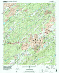
1998 Map of Leeds
USGS Topo · Published 2001About this map
Leeds and the surrounding ridgelines of the Cahaba Valley define this landscape, where the Cahaba River winds through a complex terrain of parallel ridges like Blackjack Ridge and Oak Mountain. The industrial and transit identity of the area is underscored by the dense network of rail lines, including the Norfolk Southern RR and CSX Transportation, which supported local extraction sites such as the Shale Pit and Sand Pit.
Find a feature on this map
72 named features on this map. Tap any name to fly to it.
Don’t see what you’re looking for? This feature index may not catch every label — zoom into the map to look around manually.
Map Details
Editions of this 1998 Leeds Map
This is the sole edition of this map. No revisions or reprints were ever made.
Other maps of this area

1889 · Springville
USGS Topo · 1:125,000

1889 · Birmingham
USGS Topo · 1:125,000

1890 · Bessemer
USGS Topo · 1:125,000

1890 · Talladega
USGS Topo · 1:125,000

1892 · Birmingham
USGS Topo · 1:125,000

1892 · Springville
USGS Topo · 1:125,000

1892 · Talladega
USGS Topo · 1:125,000

1892 · Bessemer
USGS Topo · 1:125,000

1895 · Birmingham
USGS Topo · 1:125,000

1905 · Leeds
USGS Topo · 1:62,500