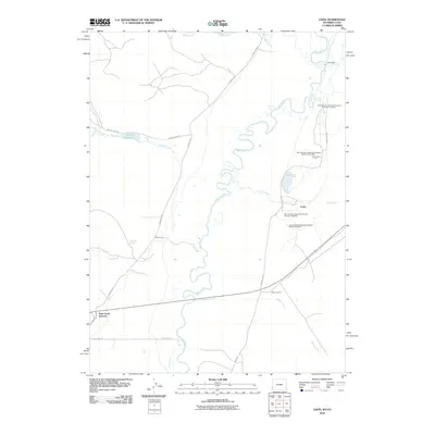
2010 Map of Leefe
USGS Topo · Published 2010About this map
Bear River meanders heavily through this 2010 survey of the Wyoming-Utah borderlands, where industrial activity and sparse ranching define the landscape. The phosphate mining operations of the San Francisco Chemical Company are prominently documented, with multiple named mine sites and pits, such as the North Forty Pit and State Line Pit, clustered around the small settlement of Leefe. This area represents a critical hub for mineral extraction in Lincoln County, evidenced by the network of heavy-duty roads like Manhead Rd and Mine Rd connecting the excavations to regional thoroughfares.
Find a feature on this map
27 named features on this map. Tap any name to fly to it.
Don’t see what you’re looking for? This feature index may not catch every label — zoom into the map to look around manually.
Map Details
Editions of this 2010 Leefe Map
This is the sole edition of this map. No revisions or reprints were ever made.
Other maps of this area

1912 · Randolph
USGS Topo · 1:125,000

1954 · Sage
USGS Topo · 1:62,500

1954 · Ogden
USGS Topo · 1:250,000

1958 · Ogden
USGS Topo · 1:250,000

1960 · Ogden
USGS Topo · 1:250,000

1962 · Windy Point
USGS Topo · 1:24,000

1968 · Rex Peak
USGS Topo · 1:24,000

1968 · Randolph
USGS Topo · 1:24,000

1969 · Sheeppen Creek
USGS Topo · 1:24,000
1969 · Leefe
USGS Topo · 1:24,000