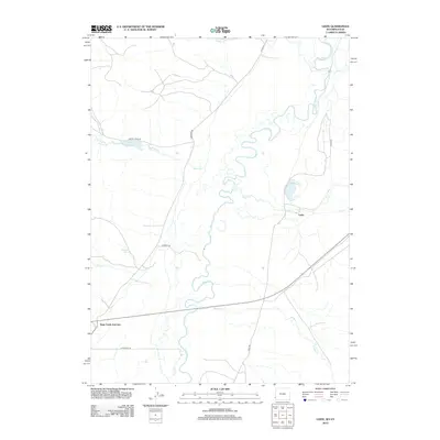
2012 Map of Leefe
USGS Topo · Published 2012About this map
The Bear River meanders extensively through this high-country landscape, its tight oxbows defining the geography of Lincoln County near the Wyoming-Utah border. The settlement of Leefe sits near the eastern edge of the quadrangle, while Sage Creek Junction serves as a navigational point in the southwest. This area is heavily defined by its water resources, with numerous named springs and creeks feeding into the larger river system.
Find a feature on this map
19 named features on this map. Tap any name to fly to it.
Don’t see what you’re looking for? This feature index may not catch every label — zoom into the map to look around manually.
Map Details
Editions of this 2012 Leefe Map
This is the sole edition of this map. No revisions or reprints were ever made.
Other maps of this area

1912 · Randolph
USGS Topo · 1:125,000

1954 · Sage
USGS Topo · 1:62,500

1954 · Ogden
USGS Topo · 1:250,000

1958 · Ogden
USGS Topo · 1:250,000

1960 · Ogden
USGS Topo · 1:250,000

1962 · Windy Point
USGS Topo · 1:24,000

1968 · Rex Peak
USGS Topo · 1:24,000

1968 · Randolph
USGS Topo · 1:24,000

1969 · Sheeppen Creek
USGS Topo · 1:24,000
1969 · Leefe
USGS Topo · 1:24,000