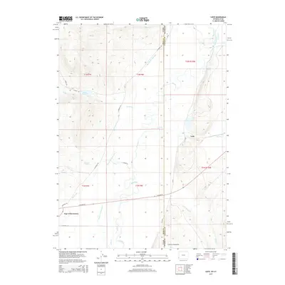
2015 Map of Leefe
USGS Topo · Published 2015About this map
Bear River meanders across the high plains of the Wyoming and Utah border, defining a landscape of intensive water management and rural settlement. The small community of Leefe sits near the eastern edge of the quadrangle, connected to the wider region via E Highway 30 and CR 220. To the southwest, Sage Creek Junction serves as a notable crossroads where local travel routes converge. The terrain is characterized by the prominent Crawford Mountains in the south, while the northern reaches are marked by an intricate network of irrigation systems including the Beckwith and Quinn Canal, McFarland Ditch, and Twin Cr Ditch.
Find a feature on this map
34 named features on this map. Tap any name to fly to it.
Don’t see what you’re looking for? This feature index may not catch every label — zoom into the map to look around manually.
Map Details
Editions of this 2015 Leefe Map
This is the sole edition of this map. No revisions or reprints were ever made.
Other maps of this area

1912 · Randolph
USGS Topo · 1:125,000

1954 · Sage
USGS Topo · 1:62,500

1954 · Ogden
USGS Topo · 1:250,000

1958 · Ogden
USGS Topo · 1:250,000

1960 · Ogden
USGS Topo · 1:250,000

1962 · Windy Point
USGS Topo · 1:24,000

1968 · Rex Peak
USGS Topo · 1:24,000

1968 · Randolph
USGS Topo · 1:24,000

1969 · Sheeppen Creek
USGS Topo · 1:24,000
1969 · Leefe
USGS Topo · 1:24,000