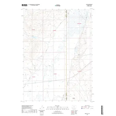
2018 Map of Leefe
USGS Topo · Published 2018About this map
The Bear River meanders across this high-desert landscape on the Wyoming-Utah border, anchoring a complex system of water management vital to the region's ranching and transit history. The settlement of Leefe sits near the eastern edge of the quadrangle, where the terrain transitions toward the uplift of the Crawford Mountains. The map reveals an intricate network of irrigation and drainage features, including the McFarland Ditch, Beckwith and Quinn Canal, and the Sage Cr Canal, which support agriculture in an otherwise arid environment. Along the western portion, Sixmile Cr flows into the Sixmile Reservoir, while numerous other waterways such as Bridger Cr and Twin Cr carve through the basin. This survey documents the intersection of natural hydrology and human engineering, where named landmarks like McKinnon Spring and Sucker Spring denote essential water sources for travelers and livestock alike.
Find a feature on this map
32 named features on this map. Tap any name to fly to it.
Don’t see what you’re looking for? This feature index may not catch every label — zoom into the map to look around manually.
Map Details
Editions of this 2018 Leefe Map
This is the sole edition of this map. No revisions or reprints were ever made.
Other maps of this area

1912 · Randolph
USGS Topo · 1:125,000

1954 · Sage
USGS Topo · 1:62,500

1954 · Ogden
USGS Topo · 1:250,000

1958 · Ogden
USGS Topo · 1:250,000

1960 · Ogden
USGS Topo · 1:250,000

1962 · Windy Point
USGS Topo · 1:24,000

1968 · Rex Peak
USGS Topo · 1:24,000

1968 · Randolph
USGS Topo · 1:24,000

1969 · Sheeppen Creek
USGS Topo · 1:24,000
1969 · Leefe
USGS Topo · 1:24,000