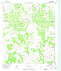
1971 Map of Lees
USGS Topo · Published 1973About this map
Glasscock County and the neighboring Howard County line define this West Texas landscape during the early 1970s. The small settlement of Lees serves as a local hub near the western edge of the quadrangle, while the drainage of the North Concho River and Panther Creek carves through the terrain. The map captures a moment of active industrial development, characterized by a sprawling Oil Field in the northeast and numerous scattered Drill Holes. These energy and agricultural pursuits are further evidenced by infrastructure like the North Cauble Windmill and several Water Tanks. For local history, the presence of a Landing Strip and an Athletic Field suggests the community's mid-century infrastructure and social spaces.
Find a feature on this map
15 named features on this map. Tap any name to fly to it.
Don’t see what you’re looking for? This feature index may not catch every label — zoom into the map to look around manually.
Map Details
Editions of this 1971 Lees Map
This is the sole edition of this map. No revisions or reprints were ever made.
Other maps of this area

1941 · Morita
USGS Topo · 1:62,500

1941 · Big Spring South
USGS Topo · 1:62,500

1942 · Big Spring South
USGS Topo · 1:62,500

1949 · Morita
USGS Topo · 1:62,500

1954 · Big Spring
USGS Topo · 1:250,000

1954 · San Angelo
USGS Topo · 1:250,000

1958 · San Angelo
USGS Topo · 1:250,000

1958 · Big Spring
USGS Topo · 1:250,000

1963 · Ballinger Ranch
USGS Topo · 1:24,000

1963 · Garden City NE
USGS Topo · 1:24,000