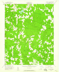
1952 Map of Lees Mill Pond
USGS Topo · Published 1959About this map
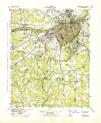
Lees Mill and the surrounding woodlands of Southside Virginia are documented here in the early 1950s, revealing a landscape defined by expansive wetlands and dispersed rural institutions. The terrain is crisscrossed by substantial water systems including Warwick Swamp, Joseph Swamp, and Jones Hole Swamp, which separate small agricultural clearings. This survey captures a network of community anchors just before the modernization of the mid-century, specifically marking numerous houses of worship such as Tar Road Ch, Salem Ch, and Mt Zion Ch. Educational centers are similarly mapped, with the locations of Providence Sch, Hakks Sch, and Templeton Sch providing critical data points for genealogists and local historians tracking the social geography of Prince George and Sussex counties. The map effectively illustrates how early settlement patterns followed the high ground between branches like Cherry Orchard Branch and Dicks Branch.
Find a feature on this map
26 named features on this map. Tap any name to fly to it.
Don’t see what you’re looking for? This feature index may not catch every label — zoom into the map to look around manually.
Map Details
Editions of this 1952 Lees Mill Pond Map
2 editions found
Other maps of this area

1894 · Petersburg
USGS Topo · 1:62,500

1919 · Jarratt
USGS Topo · 1:62,500

1919 · Disputanta
USGS Topo · 1:62,500

1919 · Homeville
USGS Topo · 1:48,000

1920 · Homeville
USGS Topo · 1:62,500
1943 · Littleton
USGS Topo · 1:31,680

1943 · Disputanta
USGS Topo · 1:31,680

1943 · Richmond
USGS Topo · 1:250,000
1944 · Reams
USGS Topo · 1:31,680
1944 · Petersburg
USGS Topo · 1:31,680