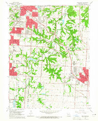
1964 Map of Lees Summit
USGS Topo · Published 1965About this map
The Little Blue River valley and its surrounding prairie landscape define this mid-1960s study of eastern Jackson County, where suburban expansion from Kansas City and Raytown begins to meet rural farmland. The map documents the established headquarters of Unity Village, featuring Unity Lake No 1 and Unity Lake No 2, alongside the growing residential developments of Ruskin Heights. The transportation network is anchored by the Chicago Rock Island and Pacific railroad, which skirts the southern edge of Lees Summit and passes through the small community of South Lee.
Find a feature on this map
64 named features on this map. Tap any name to fly to it.
Don’t see what you’re looking for? This feature index may not catch every label — zoom into the map to look around manually.
Map Details
Editions of this 1964 Lees Summit Map
4 editions found
Other maps of this area

1887 · Harrisonville
USGS Topo · 1:125,000

1887 · Olathe
USGS Topo · 1:125,000

1890 · Kansas City
USGS Topo · 1:125,000

1892 · Harrisonville
USGS Topo · 1:125,000

1893 · Olathe
USGS Topo · 1:125,000

1894 · Kansas City
USGS Topo · 1:125,000

1894 · Harrisonville
USGS Topo · 1:125,000

1894 · Independence
USGS Topo · 1:125,000

1933 · Blue Springs
USGS Topo · 1:24,000

1934 · Independence
USGS Topo · 1:24,000