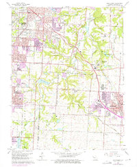
1964 Map of Lees Summit
USGS Topo · Published 1975About this map
Lees Summit and the southern outskirts of Kansas City appear in this mid-1960s survey as the suburban landscape began its significant eastward expansion. The map details the transition from rural JACKSON county to established townships, notably featuring the sprawling Unity Village complex with its specialized School of Christianity and Unity Tower. This area is characterized by a high concentration of educational and religious institutions, ranging from local schools like Robinson Sch to the Kansas City Metropolitan Jr College.
Find a feature on this map
72 named features on this map. Tap any name to fly to it.
Don’t see what you’re looking for? This feature index may not catch every label — zoom into the map to look around manually.
Map Details
Editions of this 1964 Lees Summit Map
4 editions found
Other maps of this area

1887 · Harrisonville
USGS Topo · 1:125,000

1887 · Olathe
USGS Topo · 1:125,000

1890 · Kansas City
USGS Topo · 1:125,000

1892 · Harrisonville
USGS Topo · 1:125,000

1893 · Olathe
USGS Topo · 1:125,000

1894 · Kansas City
USGS Topo · 1:125,000

1894 · Harrisonville
USGS Topo · 1:125,000

1894 · Independence
USGS Topo · 1:125,000

1933 · Blue Springs
USGS Topo · 1:24,000

1934 · Independence
USGS Topo · 1:24,000