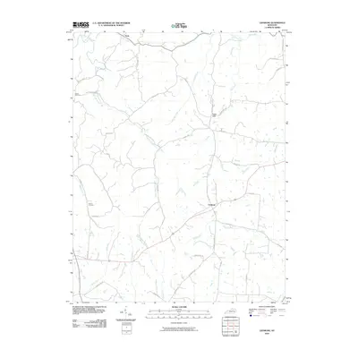
2010 Map of Leesburg
USGS Topo · Published 2010About this map
Leesburg and the rural crossroads of Lees Lick anchor this portion of the Bluegrass region, where a dense network of pikes and lanes follows the drainage of East Fork Eagle Creek. The landscape is defined by its watercourses, with Little Mill Creek, Mill Creek, and Silas Creek carving through the terrain. Family names and local history are preserved in the road network, which includes Coppage Pike, Finnell Pike, and Shropshire Ln. Researchers will find significant genealogical sites such as Hinton Cemetery near the northern forks and Sharon Cemetery situated along Sharon Branch. The map reveals a transition from traditional agricultural pikes to more modern routes like Leesburg Rd, illustrating the enduring settlement patterns in this part of Kentucky.
Find a feature on this map
43 named features on this map. Tap any name to fly to it.
Don’t see what you’re looking for? This feature index may not catch every label — zoom into the map to look around manually.
Map Details
Editions of this 2010 Leesburg Map
This is the sole edition of this map. No revisions or reprints were ever made.
Other maps of this area

1906 · Georgetown
USGS Topo · 1:62,500

1908 · Georgetown
USGS Topo · 1:62,500

1927 · Lexington
USGS Topo · 1:48,000

1929 · Cynthiana
USGS Topo · 1:48,000

1929 · Lexington
USGS Topo · 1:62,500

1934 · Cynthiana
USGS Topo · 1:62,500

1939 · Sadieville
USGS Topo · 1:62,500

1953 · Sadieville
USGS Topo · 1:24,000

1953 · Breckinridge
USGS Topo · 1:24,000
1953 · Cynthiana
USGS Topo · 1:24,000