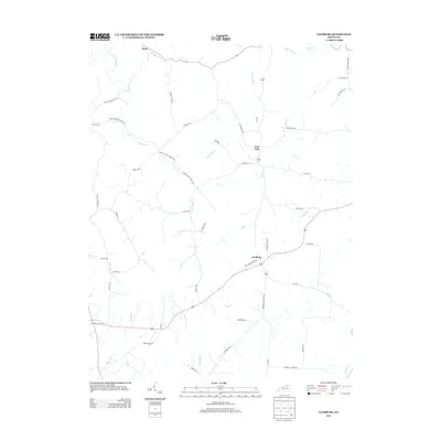
2013 Map of Leesburg
USGS Topo · Published 2013About this map
Leesburg and the surrounding Harrison County farmland are depicted here in 2013, characterized by a dense network of pikes and runs that define this Kentucky landscape. The area is dominated by the topography of Dividing Ridge Rd S, which separates the drainages of E Fork Eagle Cr and Little Mill Cr. This survey provides a precise look at the rural road system, from the Leesburg Pike to winding local routes like Davis Turkeyfoot Rd and Mount Gilead Church Rd N. Genealogists will find value in the clear location of Hinton Cem and Sharon Cem, while the small clusters at Lees Lick and Davis illustrate the enduring settlement patterns of the Bluegrass region. The map also traces significant waterways like Silas Cr and Grays Run, which have influenced the orientation of the historical property lines and roads.
Find a feature on this map
50 named features on this map. Tap any name to fly to it.
Don’t see what you’re looking for? This feature index may not catch every label — zoom into the map to look around manually.
Map Details
Editions of this 2013 Leesburg Map
This is the sole edition of this map. No revisions or reprints were ever made.
Other maps of this area

1906 · Georgetown
USGS Topo · 1:62,500

1908 · Georgetown
USGS Topo · 1:62,500

1927 · Lexington
USGS Topo · 1:48,000

1929 · Cynthiana
USGS Topo · 1:48,000

1929 · Lexington
USGS Topo · 1:62,500

1934 · Cynthiana
USGS Topo · 1:62,500

1939 · Sadieville
USGS Topo · 1:62,500

1953 · Sadieville
USGS Topo · 1:24,000

1953 · Breckinridge
USGS Topo · 1:24,000
1953 · Cynthiana
USGS Topo · 1:24,000