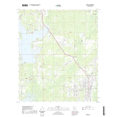
2020 Map of Leesville
USGS Topo · Published 2020About this map
Leesville serves as the central hub of this West Louisiana landscape, anchored by the Vernon Parish Courthouse and a dense network of local streets. The geography is defined by a transition from the urban center to the timbered creek bottoms and reservoirs that dominate the parish. To the north, the settlement of Anacoco sits near the upper reaches of Vernon Lake, while Hawthorne occupies the corridor leading back toward the city. The area is notable for its numerous burial grounds, including the Holly Grove, Pine Hill, and Shady Grove cemeteries, which offer valuable data for genealogical research.
Find a feature on this map
161 named features on this map. Tap any name to fly to it.
Don’t see what you’re looking for? This feature index may not catch every label — zoom into the map to look around manually.
Map Details
Editions of this 2020 Leesville Map
This is the sole edition of this map. No revisions or reprints were ever made.
Other maps of this area

1941 · Leesville
USGS Topo · 1:62,500

1941 · Slagle
USGS Topo · 1:62,500

1942 · Florien
USGS Topo · 1:62,500

1942 · Kisatchie
USGS Topo · 1:62,500

1943 · Leesville
USGS Topo · 1:62,500

1943 · Kisatchie
USGS Topo · 1:62,500

1944 · Florien
USGS Topo · 1:62,500

1944 · Slagle
USGS Topo · 1:62,500

1946 · Leesville
USGS Topo · 1:62,500

1948 · Leesville
USGS Topo · 1:62,500