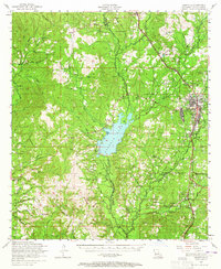
1954 Map of Leesville
USGS Topo · Published 1965About this map
Leesville serves as the primary hub of this Vernon Parish landscape during the mid-1950s, shown just as the town's footprint begins to expand with facilities like the J B Younger Infirmary and Leesville High School. The Kansas City Southern railroad remains the dominant industrial corridor, though several stretches of dismantled railroad through the piney woods indicate the shifting nature of the local timber economy. West of the town center, Anacoco Lake stands as a significant geographic anchor, fed by Caney Creek and Buck Creek.
Find a feature on this map
92 named features on this map. Tap any name to fly to it.
Don’t see what you’re looking for? This feature index may not catch every label — zoom into the map to look around manually.
Map Details
Editions of this 1954 Leesville Map
4 editions found
Other maps of this area

1941 · Leesville
USGS Topo · 1:62,500

1941 · Slagle
USGS Topo · 1:62,500

1942 · Florien
USGS Topo · 1:62,500

1942 · Kisatchie
USGS Topo · 1:62,500

1943 · Leesville
USGS Topo · 1:62,500

1943 · Kisatchie
USGS Topo · 1:62,500

1944 · Negreet
USGS Topo · 1:62,500

1944 · Wiergate
USGS Topo · 1:62,500

1944 · Florien
USGS Topo · 1:62,500

1944 · Slagle
USGS Topo · 1:62,500