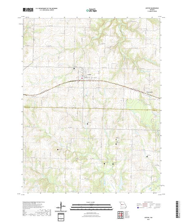
2021 Map of Leeton
USGS Topo · Published 2021About this map
Leeton serves as the central hub of this Missouri landscape, situated where the Rock Island Spur Trl crosses the prairie. This former rail corridor, now a recreational path, anchors the community and passes through the smaller settlement of New Castle to the east. The terrain is defined by a dense network of small waterways, including Mineral Cr, Little Tebo Cr, and the Clear Fork Blackwater River, which carve subtle valleys through the farmland. For genealogists and local historians, this survey is particularly valuable for its high density of rural burial grounds. Scattered across the countryside are numerous historical sites such as Mineral Creek Cem, Fewel Cem, Wade Cem, and the dual Sardis North Cem and Sardis South Cem. These landmarks, along with Salem Cem and Hickory Grove Cem, provide a clear picture of the early family settlements and parish boundaries that formed the backbone of Johnson and Henry counties.
Find a feature on this map
75 named features on this map. Tap any name to fly to it.
Don’t see what you’re looking for? This feature index may not catch every label — zoom into the map to look around manually.
Map Details
Editions of this 2021 Leeton Map
This is the sole edition of this map. No revisions or reprints were ever made.
Other maps of this area

1885 · Warrensburg
USGS Topo · 1:125,000

1887 · Clinton
USGS Topo · 1:125,000

1887 · Warrensburg
USGS Topo · 1:125,000

1894 · Warrensburg
USGS Topo · 1:125,000

1894 · Clinton
USGS Topo · 1:125,000

1947 · Jefferson City
USGS Topo · 1:250,000
1953 · Calhoun East
USGS Topo · 1:24,000

1953 · Calhoun West
USGS Topo · 1:24,000
1953 · Clinton North
USGS Topo · 1:24,000

1954 · Jefferson City
USGS Topo · 1:250,000