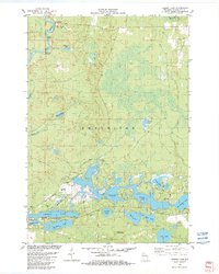
1982 Map of Legend Lake
USGS Topo · Published 1982About this map
The Wolf River dominates the northwestern corner of this landscape, carving through the terrain near Turtle Rapids and White Rapids. Much of the area is defined by the complex water system of Legend Lake, which branches out into numerous bays and channels. This 1982 survey reveals a land transition, where the sprawling Menominee boundary contains a network of smaller water bodies like Waukau Lake and Rushes Lake north of the primary lake system. Culturally, the map documents established local sites including St Michael Cem and Rest Haven Cem. A distinct recreational and wilderness infrastructure is visible through the South Branch Pathway and various trails like the Spotted Fawn Trail, while the Sand Lake Lookout Tower stands as a sentinel over the southern woods near Sand Lake and Little Sand Lake.
Find a feature on this map
35 named features on this map. Tap any name to fly to it.
Don’t see what you’re looking for? This feature index may not catch every label — zoom into the map to look around manually.
Map Details
Editions of this 1982 Legend Lake Map
This is the sole edition of this map. No revisions or reprints were ever made.
Other maps of this area

1942 · Breed
USGS Topo · 1:48,000

1952 · Langlade
USGS Topo · 1:48,000

1952 · Mountain
USGS Topo · 1:48,000

1954 · Shawano
USGS Topo · 1:48,000

1954 · Iron Mountain
USGS Topo · 1:250,000

1955 · Green Bay
USGS Topo · 1:250,000

1956 · Gillett
USGS Topo · 1:62,500

1959 · Iron Mountain
USGS Topo · 1:250,000

1964 · Shawano
USGS Topo · 1:62,500
1973 · Fredenberg Lake
USGS Topo · 1:24,000