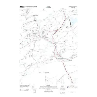
2013 Map of Lehighton
USGS Topo · Published 2013About this map
The Lehigh River carves a deep path through Carbon County, anchoring a dense network of riverfront settlements including Lehighton, Weissport, and Jim Thorpe. This 2013 survey reveals the industrial and transport heritage of the region, where the Lehigh Valley Tunnel and various junctions like Packerton Junction and Lizard Creek Junction mark the historic movement of goods through the valley. The landscape transitions from the residential streets of Union Hill and North Weissport to the recreational waters of Beltzville Lake and the high vantage point of the Flagstaff Mountain Overlook. To the north, the Lehigh Gorge provides a dramatic natural boundary, while the Indian Hills and Stone Ridge define the local topography. Modern infrastructure is represented by the Pennsylvania Turnpike Interchange 34, showing how contemporary travel routes have overlaid the older patterns of the Mahoning Valley.
Find a feature on this map
260 named features on this map. Tap any name to fly to it.
Don’t see what you’re looking for? This feature index may not catch every label — zoom into the map to look around manually.
Map Details
Editions of this 2013 Lehighton Map
This is the sole edition of this map. No revisions or reprints were ever made.
Other maps of this area

1889 · Hazleton
USGS Topo · 1:62,500

1891 · Hazleton
USGS Topo · 1:62,500

1893 · Hazleton
USGS Topo · 1:62,500

1902 · Slatington
USGS Topo · 1:62,500

1909 · Hamburg
USGS Topo · 1:62,500

1911 · Hamburg
USGS Topo · 1:62,500

1922 · Mauch Chunk
USGS Topo · 1:62,500

1924 · Mauch Chunk
USGS Topo · 1:62,500

1937 · Allentown West
USGS Topo · 1:48,000

1942 · Allentown West
USGS Topo · 1:62,500