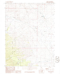
1986 Map of Lehman Caves
USGS Topo · Published 1986About this map
Lehman Caves National Monument sits at the heart of this high-altitude landscape, protecting the subterranean formations of the Lehman Caves system. This mid-1980s provisional study details a transition from the public recreational lands of the Humboldt National Forest to the arid alluvial fans of the Great Basin. Water management is a primary theme of the area's development, evidenced by the Silver Creek Reservoir, numerous irrigation ditches, and the proximity of seasonal drainages like Miller Basin Wash and Lehman Creek. Local history is anchored by small-scale features including a remote Cem, scattered prospects, and infrastructure such as a substation and sewage disposal pond near the monument's entrance. The map provides a clear look at the primitive road network and pipelines that supported ranching and tourism in this corner of White Pine County.
Find a feature on this map
29 named features on this map. Tap any name to fly to it.
Don’t see what you’re looking for? This feature index may not catch every label — zoom into the map to look around manually.
Map Details
Editions of this 1986 Lehman Caves Map
2 editions found
Other maps of this area

1948 · Wheeler Peak
USGS Topo · 1:62,500

1949 · Garrison
USGS Topo · 1:62,500

1950 · Wheeler Peak
USGS Topo · 1:62,500

1951 · Garrison
USGS Topo · 1:62,500

1956 · Lund
USGS Topo · 1:250,000

1956 · Ely
USGS Topo · 1:250,000

1959 · Ely
USGS Topo · 1:250,000

1959 · Sacramento Pass
USGS Topo · 1:62,500

1960 · Lund
USGS Topo · 1:250,000

1963 · Ely
USGS Topo · 1:250,000