
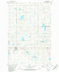
1982 Map of Lehr SW
USGS Topo · Published 1983About this map
Logan County State Game Management Area and the National Waterfowl Production Area dominate this section of the prairie pothole region during the early 1980s. The landscape is defined by its glacial hydrology, featuring numerous unnamed wetlands alongside Doyles Lake and Mud Lake. Cultural landmarks are concentrated near the county line, where Ebenezer Ch and a local Cem serve the rural community. The Soo Line railroad cuts through the southern portion of the map, reflecting the importance of rail transport for this agricultural and resource-rich area. Small-scale industrial activity is evident in the scattered Gravel Pits and the infrastructure of the Lehr Dam, which manages local water levels in a region characterized by its shifting lake margins and drainage patterns across the Logan and McIntosh county border.
Find a feature on this map
11 named features on this map. Tap any name to fly to it.
Don’t see what you’re looking for? This feature index may not catch every label — zoom into the map to look around manually.
Map Details
Editions of this 1982 Lehr SW Map
This is the sole edition of this map. No revisions or reprints were ever made.
Other maps of this area

1953 · Jamestown
USGS Topo · 1:250,000

1956 · Jamestown
USGS Topo · 1:250,000

1982 · Danzig
USGS Topo · 1:24,000

1982 · Wishek NE
USGS Topo · 1:24,000

1982 · May Lake
USGS Topo · 1:24,000

1982 · Lehr NW
USGS Topo · 1:24,000

1982 · Lehr NE
USGS Topo · 1:24,000

1982 · Ashley NE
USGS Topo · 1:24,000

1982 · Wishek
USGS Topo · 1:24,000
1982 · Lehr
USGS Topo · 1:24,000