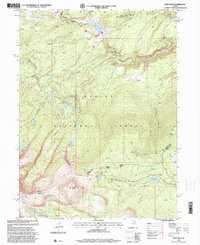
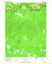
1996 Map of Leidy Peak
USGS Topo · Published 2000About this map
Ashley National Forest dominates the high-altitude landscape of this 1990s revision, which documents the complex drainage systems and historical transit routes across the Uinta Mountains. The presence of the Carter Military Trail and its predecessor, the Military Trail, highlights the era of frontier movement through difficult terrain like the Icy Hill Dugway. Water management is a central theme of the topography, with the Beaver Canal and several mountain reservoirs, including Long Park Reservoir and Browne Lake, supporting activities below the timberline.
Find a feature on this map
44 named features on this map. Tap any name to fly to it.
Don’t see what you’re looking for? This feature index may not catch every label — zoom into the map to look around manually.
Map Details
Editions of this 1996 Leidy Peak Map
This is the sole edition of this map. No revisions or reprints were ever made.
Other maps of this area

1885 · Ashley
USGS Topo · 1:250,000

1906 · Marsh Peak
USGS Topo · 1:125,000

1908 · Marsh Peak
USGS Topo · 1:125,000

1954 · Vernal
USGS Topo · 1:250,000

1958 · Vernal
USGS Topo · 1:250,000

1960 · Vernal
USGS Topo · 1:250,000
1963 · Whiterocks Lake
USGS Topo · 1:24,000
1963 · Manila
USGS Topo · 1:24,000
1963 · Leidy Peak
USGS Topo · 1:24,000
1963 · Elk Park
USGS Topo · 1:24,000