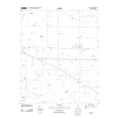
2011 Map of Leighton
USGS Topo · Published 2011About this map
LaGrange Mountain and the heights of Duke Mountain overlook a landscape of longstanding family settlements and agricultural roots in this Colbert County study. The town of Leighton serves as a primary hub, surrounded by a dense network of local landmarks including Valley Grove, Whiteoak, and Spring Valley. For those researching local lineages, the map identifies over a dozen burial sites such as Glendale Cemetery, Blythe Memorial Cemetery, and Rand Cemetery. Drainage patterns are defined by Dry Creek and Pond Creek, which wind through lowlands like Abernathy Bottom and Gum Bottom. The presence of the Muscle Shoals Regional Airport in the northwest and Emco-Listerhill Junction indicates the modern industrial and transportation infrastructure that has integrated with these traditional rural communities.
Find a feature on this map
96 named features on this map. Tap any name to fly to it.
Don’t see what you’re looking for? This feature index may not catch every label — zoom into the map to look around manually.
Map Details
Editions of this 2011 Leighton Map
This is the sole edition of this map. No revisions or reprints were ever made.
Other maps of this area

1914 · Rogersville
USGS Topo · 1:48,000

1914 · Muscle Shoals
USGS Topo · 1:48,000

1916 · Muscle Shoals
USGS Topo · 1:62,500

1916 · Rogersville
USGS Topo · 1:62,500

1924 · Tuscumbia
USGS Topo · 1:48,000

1926 · Tuscumbia
USGS Topo · 1:62,500

1936 · Russellville
USGS Topo · 1:24,000

1936 · Wheeler Dam
USGS Topo · 1:24,000

1936 · Florence
USGS Topo · 1:24,000

1936 · Town Creek
USGS Topo · 1:24,000