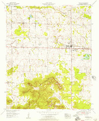
1952 Map of Leighton
USGS Topo · Published 1957About this map
La Grange Mountain dominates the southern landscape of this 1950s survey, marking a significant transition from the agricultural plains of the Tennessee Valley. The summit area preserves local history through the La Grange College Monument and La Grange Cem, overlooking the community of Leighton. The Southern railway and the Joe Wheeler Highway serve as the primary east-west transportation arteries, connecting the rural settlements of Spring Valley and several country churches like Galilee Ch and Ricks Ch.
Find a feature on this map
48 named features on this map. Tap any name to fly to it.
Don’t see what you’re looking for? This feature index may not catch every label — zoom into the map to look around manually.
Map Details
Editions of this 1952 Leighton Map
This is the sole edition of this map. No revisions or reprints were ever made.
Other maps of this area

1914 · Rogersville
USGS Topo · 1:48,000

1914 · Muscle Shoals
USGS Topo · 1:48,000

1916 · Muscle Shoals
USGS Topo · 1:62,500

1916 · Rogersville
USGS Topo · 1:62,500

1924 · Tuscumbia
USGS Topo · 1:48,000

1926 · Tuscumbia
USGS Topo · 1:62,500

1936 · Russellville
USGS Topo · 1:24,000

1936 · Wheeler Dam
USGS Topo · 1:24,000

1936 · Florence
USGS Topo · 1:24,000

1936 · Town Creek
USGS Topo · 1:24,000