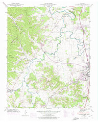
1946 Map of Leipers Fork
USGS Topo · Published 1974About this map
Natchez Trace Pike cuts through this landscape, marking a corridor of settlement and history just west of Franklin. The area is defined by the winding course of the Harpeth River and its various bends, including Lumsden Bend and Baugh Bend. Rural life is centered around numerous crossroads and small communities such as Leipers Fork, Forest Home, and Bingham. The presence of several country churches and schools, such as Hogeye Ch and Hillsboro Sch, suggests a tightly knit social fabric during the mid-20th century.
Find a feature on this map
58 named features on this map. Tap any name to fly to it.
Don’t see what you’re looking for? This feature index may not catch every label — zoom into the map to look around manually.
Map Details
Editions of this 1946 Leipers Fork Map
2 editions found
Other maps of this area

1901 · Colombia
USGS Topo · 1:125,000

1903 · Nashville
USGS Topo · 1:125,000

1909 · Franklin
USGS Topo · 1:62,500

1930 · White Bluff
USGS Topo · 1:62,500

1932 · Nashville
USGS Topo · 1:62,500

1933 · White Bluff
USGS Topo · 1:62,500

1936 · Spring Hill
USGS Topo · 1:24,000

1936 · Theta
USGS Topo · 1:24,000

1936 · Bethesda
USGS Topo · 1:24,000

1946 · Leipers Fork
USGS Topo · 1:24,000