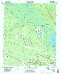
1984 Map of Leland
USGS Topo · Published 1984About this map
The Cape Fear River and Black River converge in this coastal North Carolina landscape, where industrial infrastructure meets low-lying wetlands. In the early 1980s, the area's economy is clearly defined by the Seaboard Coast Line Railroad and the massive Davis Yard, alongside heavy industry indicated by the Industrial Waste Ponds near the riverbanks. Local genealogy and community history are anchored by numerous small landmarks, including the Lincoln Sch and several country churches like New Hope Ch and Johnson Chapel.
Find a feature on this map
79 named features on this map. Tap any name to fly to it.
Don’t see what you’re looking for? This feature index may not catch every label — zoom into the map to look around manually.
Map Details
Editions of this 1984 Leland Map
2 editions found
Other maps of this area

1942 · Wilmington
USGS Topo · 1:62,500

1943 · Winnabow
USGS Topo · 1:24,000

1943 · Lewis Swamp
USGS Topo · 1:24,000

1944 · Winnabow
USGS Topo · 1:31,680

1944 · Lewis Swamp
USGS Topo · 1:31,680

1947 · Rocky Point
USGS Topo · 1:62,500

1948 · Wilmington
USGS Topo · 1:62,500

1950 · Winnabow
USGS Topo · 1:25,000

1953 · Florence
USGS Topo · 1:250,000

1953 · Beaufort
USGS Topo · 1:250,000