1965 Map of Lemhi Pass
USGS Topo · Published 1979About this map
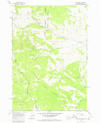
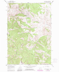
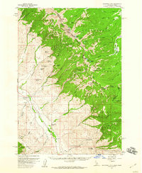
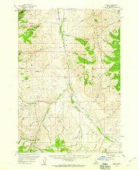
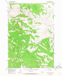
The Continental Divide serves as the primary spine of this mid-1960s survey, marking the high-altitude border between Idaho and Montana. This rugged corridor is defined by the historic Lemhi Pass, a critical crossing point between the Salmon National Forest and the Beaverhead National Forest. The landscape reveals a history of early mining and recreation, notably at the Sacajawea Memorial Camp and the Copper Queen Mine. Small outposts like Agency and the Selway Ranch are connected by a network of primitive tracks, labeled as Jeep Trails, which navigate the headwaters of numerous mountain drainages. The map details a complex hydrographic system where North Frying Pan Creek and South Frying Pan Creek flow toward the Pacific, while eastern slopes feed into Shearer Creek and Bear Creek. Researchers will find numerous unnamed Mine and Prospects markers scattered across the ridges, indicating the intense mineral exploration that characterized the region’s development.
Find a feature on this map
30 named features on this map. Tap any name to fly to it.
Don’t see what you’re looking for? This feature index may not catch every label — zoom into the map to look around manually.
Map Details
Editions of this 1965 Lemhi Pass Map
3 editions found
Other maps of this area

1955 · Dubois
USGS Topo · 1:250,000

1955 · Dillon
USGS Topo · 1:250,000
1956 · Goldstone Mtn
USGS Topo · 1:62,500
1956 · Lemhi
USGS Topo · 1:62,500

1957 · Dillon
USGS Topo · 1:250,000

1958 · Dubois
USGS Topo · 1:250,000

1958 · Dillon
USGS Topo · 1:250,000

1962 · Dillon
USGS Topo · 1:250,000

1965 · Dillon
USGS Topo · 1:250,000
1965 · Lemhi Pass
USGS Topo · 1:24,000