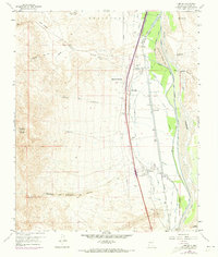
1959 Map of Lemitar
USGS Topo · Published 1973About this map
The Rio Grande corridor north of Socorro is defined here by a sophisticated network of mid-century irrigation and flood control engineering. The landscape is divided between the arid western uplands of Polvadera Mountain and the fertile valley floor, where the San Lorenzo Settling Basin and numerous ditches like the Alamillo Ditch and Lemitar Ditch manage the river's flow. Small agricultural communities such as Chamizal, Polvadera, and Lemitar are situated along the Atchison Topeka and Santa Fe Railway, which runs parallel to the modern corridor of Interstate 25. This 1959 survey, updated with 1971 aerial data, captures the transition of the valley as the traditional Contra Acequia system operated alongside large-scale industrial features like the Lemitar Wasteway and several Gravel Pits. Local history is preserved in the location of a village Cem and the winding course of the Cañoncito del Puertecito del Lemitar.
Find a feature on this map
42 named features on this map. Tap any name to fly to it.
Don’t see what you’re looking for? This feature index may not catch every label — zoom into the map to look around manually.
Map Details
Editions of this 1959 Lemitar Map
2 editions found
Other maps of this area

1906 · Socorro
USGS Topo · 1:62,500

1916 · La Joya
USGS Topo · 1:125,000

1952 · San Anacia
USGS Topo · 1:24,000

1952 · La Joya
USGS Topo · 1:24,000

1954 · Socorro
USGS Topo · 1:250,000

1958 · Socorro
USGS Topo · 1:250,000

1959 · Loma De Las Canas
USGS Topo · 1:24,000

1959 · Socorro
USGS Topo · 1:24,000

1959 · Mesa Del Yeso
USGS Topo · 1:24,000

1959 · Lemitar
USGS Topo · 1:24,000