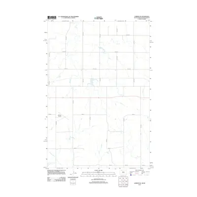
2012 Map of Lemmon NE
USGS Topo · Published 2012About this map
Plum Creek meanders through the northern section of this high plains landscape, feeding into Township Lake as the terrain slopes toward the South Dakota-North Dakota border. The area is defined by a rigorous section-line grid of rural roads, including 27th St SE and 197th Ave, which facilitate movement across this expansive agricultural and grazing district. In the southwest, the Lemmon Municipal Airport stands as a significant landmark, situated near Airport Road. Further south, the drainage of Thunder Hawk Creek cuts through the prairie, marking the lower reaches of the quadrangle near Reidy Road. This 2012 survey illustrates the modern layout of rural infrastructure in the Rock Creek District, where natural watercourses remain the primary geographic anchors amidst the straight-line development of the county road system.
Find a feature on this map
23 named features on this map. Tap any name to fly to it.
Don’t see what you’re looking for? This feature index may not catch every label — zoom into the map to look around manually.
Map Details
Editions of this 2012 Lemmon NE Map
This is the sole edition of this map. No revisions or reprints were ever made.
Other maps of this area

1953 · McIntosh
USGS Topo · 1:250,000

1953 · Dickinson
USGS Topo · 1:250,000

1954 · Lemmon
USGS Topo · 1:250,000

1954 · Bismarck
USGS Topo · 1:250,000

1957 · Dickinson
USGS Topo · 1:250,000

1957 · Lemmon
USGS Topo · 1:250,000

1958 · Bismarck
USGS Topo · 1:250,000

1958 · McIntosh
USGS Topo · 1:250,000

1972 · Round Top
USGS Topo · 1:24,000

1972 · Thunder Hawk SW
USGS Topo · 1:24,000