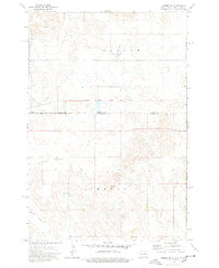
1974 Map of Lemmon NE
USGS Topo · Published 1978About this map
The Chicago Milwaukee St Paul and Pacific railroad bisects this Dakota landscape, tracing a horizontal path along the border of Adams and Perkins Counties. The map captures the interface between North and South Dakota in the 1970s, defined by large land tracts and the sprawling Standing Rock Indian Reservation Boundary to the east. Transportation and aviation infrastructure are central to this area, anchored by the Lemmon Municipal Airport with its associated Beacon and adjacent Golf Course. Natural drainage is defined by the winding course of Plum Creek and Thunder Hawk Creek, which cut through the high plains. Industrial activity is sparsely represented by a Gravel Pit near the northern boundary of Orange township, while Township Lake provides a rare localized water feature in this expansive ranching and agricultural region.
Find a feature on this map
14 named features on this map. Tap any name to fly to it.
Don’t see what you’re looking for? This feature index may not catch every label — zoom into the map to look around manually.
Map Details
Editions of this 1974 Lemmon NE Map
This is the sole edition of this map. No revisions or reprints were ever made.
Other maps of this area

1953 · McIntosh
USGS Topo · 1:250,000

1953 · Dickinson
USGS Topo · 1:250,000

1954 · Lemmon
USGS Topo · 1:250,000

1954 · Bismarck
USGS Topo · 1:250,000

1957 · Dickinson
USGS Topo · 1:250,000

1957 · Lemmon
USGS Topo · 1:250,000

1958 · Bismarck
USGS Topo · 1:250,000

1958 · McIntosh
USGS Topo · 1:250,000

1972 · Round Top
USGS Topo · 1:24,000

1972 · Thunder Hawk SW
USGS Topo · 1:24,000