1954 Map of Lemmon
USGS Topo · Published 1979About this map
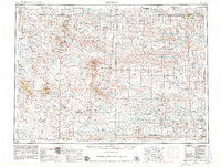
Lemmon sits at the junction of the Chicago Milwaukee St Paul and Pacific railroad and the North Dakota border, serving as a vital rail hub for the cattle and grain country of the High Plains. This landscape is defined by its dramatic buttes and scattered ranching communities like Bison, Buffalo, and Camp Crook. The topography reveals the intricate drainage systems of the North Fork and South Fork Grand River, which feed into the Shadehill Reservoir.
Find a feature on this map
105 named features on this map. Tap any name to fly to it.
Don’t see what you’re looking for? This feature index may not catch every label — zoom into the map to look around manually.
Map Details
Editions of this 1954 Lemmon Map
2 editions found

Other maps of this area

1901 · Aladdin
USGS Topo · 1:125,000

1903 · Aladdin
USGS Topo · 1:125,000
1905 · Indian
USGS Topo · 1:62,500

1906 · Two Top
USGS Topo · 1:62,500

1907 · Belle Fourche
USGS Topo · 1:125,000

1913 · Newell
USGS Topo · 1:125,000

1935 · Reva
USGS Topo · 1:125,000

1935 · Hoover
USGS Topo · 1:125,000

1935 · Harding
USGS Topo · 1:125,000

1935 · Buffalo
USGS Topo · 1:125,000