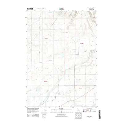
2013 Map of Lemon Lake
USGS Topo · Published 2013About this map
Henrys Fork and Fall River dominate the southern landscape of this Fremont County quadrangle, where complex irrigation networks like the Arcadia Canal, Farmers Own Canal, and Bell Ditch branch out to support local agriculture. The terrain transitions from the river bottoms to the higher ground of the Snake River Plain, marked by features such as Box Canyon and Cedar Hollow. Small settlements like Sarilda and Ora serve as quiet centers for the surrounding rural area, connected by a grid of section roads and the prominent Us-20 E corridor.
Find a feature on this map
43 named features on this map. Tap any name to fly to it.
Don’t see what you’re looking for? This feature index may not catch every label — zoom into the map to look around manually.
Map Details
Editions of this 2013 Lemon Lake Map
This is the sole edition of this map. No revisions or reprints were ever made.
Other maps of this area

1949 · Newdale
USGS Topo · 1:24,000

1950 · Newdale
USGS Topo · 1:24,000

1950 · St Anthony
USGS Topo · 1:24,000

1955 · Ashton
USGS Topo · 1:250,000

1955 · Driggs
USGS Topo · 1:250,000

1958 · Driggs
USGS Topo · 1:250,000

1958 · Ashton
USGS Topo · 1:250,000

1960 · Ashton
USGS Topo · 1:250,000

1962 · Driggs
USGS Topo · 1:250,000
1965 · Black Knoll
USGS Topo · 1:24,000