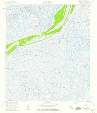
1955 Map of Lena Lagoon
USGS Topo · Published 1959About this map
Bayou La Loutre cuts through the expansive marshlands of St. Bernard Parish, flanked by long Spoil Banks that illustrate the dredging and waterway maintenance efforts of the mid-1950s. The landscape is a complex labyrinth of coastal hydrology, where named bodies of water like Lena Lagoon and Pisana Lagoon are interconnected by a network of bayous including Bayou St. Malo and Bayou Musselini. These names often reflect the cultural heritage and family lineages of the coastal fishing and trapping communities that have long navigated these wetlands.
Find a feature on this map
31 named features on this map. Tap any name to fly to it.
Don’t see what you’re looking for? This feature index may not catch every label — zoom into the map to look around manually.
Map Details
Editions of this 1955 Lena Lagoon Map
2 editions found
Other maps of this area

1893 · La Fortuna
USGS Topo · 1:62,500

1893 · Shell Beach
USGS Topo · 1:62,500

1893 · Dime
USGS Topo · 1:62,500

1895 · Bodreau
USGS Topo · 1:62,500

1935 · Lake Athanasio
USGS Topo · 1:31,680

1935 · Lake Calebasse
USGS Topo · 1:31,680

1939 · Shell Beach
USGS Topo · 1:62,500

1941 · Black Bay
USGS Topo · 1:62,500

1941 · Shell Beach
USGS Topo · 1:62,500
1944 · Black Bay
USGS Topo · 1:62,500