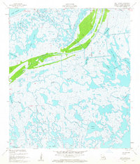
1955 Map of Lena Lagoon
USGS Topo · Published 1963About this map
Bayou La Loutre cuts a prominent path through the wetlands of St. Bernard Parish in the mid-1950s, flanked by an extensive Spoil Bank system that illustrates the early engineering of Louisiana's coastal waterways. The landscape is a dense network of marshes and brackish water bodies, where larger features like Lena Lagoon and Magnolia Lagoon are connected by intricate channels such as Bayou St. Malo and Bayou Musselini. This survey, compiled from 1952 aerial photography, documents the coastal topography before significant modern subsidence and erosion altered the region. The presence of the Engineers Canal and Bakers Canal suggests a history of maritime access and drainage efforts, while locally named water bodies like Lake Jean Louis Robin and Lake Coquille provide specific geographic markers for genealogists and local historians tracking family connections to these marshlands.
Find a feature on this map
27 named features on this map. Tap any name to fly to it.
Don’t see what you’re looking for? This feature index may not catch every label — zoom into the map to look around manually.
Map Details
Editions of this 1955 Lena Lagoon Map
2 editions found
Other maps of this area

1893 · La Fortuna
USGS Topo · 1:62,500

1893 · Shell Beach
USGS Topo · 1:62,500

1893 · Dime
USGS Topo · 1:62,500

1895 · Bodreau
USGS Topo · 1:62,500

1935 · Lake Athanasio
USGS Topo · 1:31,680

1935 · Lake Calebasse
USGS Topo · 1:31,680

1939 · Shell Beach
USGS Topo · 1:62,500

1941 · Black Bay
USGS Topo · 1:62,500

1941 · Shell Beach
USGS Topo · 1:62,500
1944 · Black Bay
USGS Topo · 1:62,500