
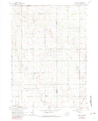
1962 Map of Lennox NW
USGS Topo · Published 1964About this map
The agrarian plains of southeastern South Dakota are defined here by a dense network of one-room schoolhouses and rural townships, illustrating the mid-century peak of established family farming. Distributed across the landscape are numerous named educational landmarks including Dirksen Sch, Goldenrod Sch, Home Sch, and Berena Sch, each serving the surrounding sections of Home, Delapre, Germantown, and Perry townships. The village of Chancellor sits at the intersection of the C M St P & P and Great Northern railroads, marking it as a local hub for transport and trade.
Find a feature on this map
24 named features on this map. Tap any name to fly to it.
Don’t see what you’re looking for? This feature index may not catch every label — zoom into the map to look around manually.
Map Details
Editions of this 1962 Lennox NW Map
2 editions found
Other maps of this area

1897 · Canton
USGS Topo · 1:125,000

1898 · Parker
USGS Topo · 1:125,000

1900 · Canton
USGS Topo · 1:125,000

1955 · Sioux Falls
USGS Topo · 1:250,000

1958 · Sioux Falls
USGS Topo · 1:250,000

1962 · Tea
USGS Topo · 1:24,000

1962 · Hartford South
USGS Topo · 1:24,000

1962 · Sioux Falls West
USGS Topo · 1:24,000

1964 · Worthing
USGS Topo · 1:24,000

1964 · Grass Lake
USGS Topo · 1:24,000