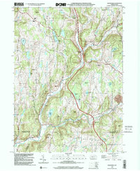
1999 Map of Lenoxville
USGS Topo · Published 2001About this map
Tunk Hannock Creek and its East Branch carve a complex landscape of ridges and basins through the heart of Susquehanna County. At the end of the twentieth century, this region maintained a distinctly rural character, with small crossroads settlements like Lenoxville and West Lenox serving as anchor points for the surrounding hills. Historical markers of community life remain prominent, including the West Lenox Ch and a network of educational sites like the Wright Sch and Green Grove Sch. The topography is defined by named peaks such as Morgan Hill, Jeffers Hill, and Hickory Ridge, which separate the various watersheds. Local history is etched into the land through family-named landmarks like Harding Corners Cem and the extensive Tamarack Swamp, illustrating the long-standing relationship between the residents and the varied terrain of the Endless Mountains region.
Find a feature on this map
55 named features on this map. Tap any name to fly to it.
Don’t see what you’re looking for? This feature index may not catch every label — zoom into the map to look around manually.
Map Details
Editions of this 1999 Lenoxville Map
2 editions found
Other maps of this area

1892 · Dundaff
USGS Topo · 1:62,500

1932 · Susquehanna
USGS Topo · 1:62,500

1935 · Susquehanna
USGS Topo · 1:62,500

1943 · Montrose
USGS Topo · 1:62,500

1945 · Montrose
USGS Topo · 1:62,500

1946 · Tunkhannock
USGS Topo · 1:62,500

1946 · Dalton
USGS Topo · 1:24,000

1946 · Carbondale
USGS Topo · 1:24,000

1946 · Factoryville
USGS Topo · 1:24,000
1946 · Clifford
USGS Topo · 1:24,000