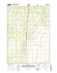
2014 Map of Lenz
USGS Topo · Published 2014About this map
Winema National Forest and the Antelope Desert define the high-plateau landscape of this Klamath County region. The settlement of Lenz serves as a central point in a grid of forest roads and historic routes, including the Military Rd and Sun Mountain Rd. Water features are critical markers in this arid environment, with Big Springs feeding into Big Springs Cr to the east, while Cow Cr and Scott Cr meander through the central plains. The map reveals a transition from the structured forestry boundaries to more developed clusters of residential streets like Artesian Dr and Jager St further south. This network of timber access and small-scale settlement illustrates the 21st-century character of the area, where modern infrastructure follows the paths of earlier pioneers and foresters.
Find a feature on this map
32 named features on this map. Tap any name to fly to it.
Don’t see what you’re looking for? This feature index may not catch every label — zoom into the map to look around manually.
Map Details
Editions of this 2014 Lenz Map
This is the sole edition of this map. No revisions or reprints were ever made.
Other maps of this area

1889 · Klamath
USGS Topo · 1:250,000

1894 · Klamath
USGS Topo · 1:250,000

1935 · Chemult
USGS Topo · 1:96,000

1941 · Chemult
USGS Topo · 1:125,000

1955 · Crescent
USGS Topo · 1:250,000

1955 · Klamath Falls
USGS Topo · 1:250,000

1957 · Crescent
USGS Topo · 1:250,000

1957 · Klamath Marsh
USGS Topo · 1:62,500

1957 · Lenz
USGS Topo · 1:62,500

1958 · Crescent
USGS Topo · 1:250,000