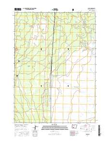
2017 Map of Lenz
USGS Topo · Published 2017About this map
Klamath Marsh National Wildlife Refuge and the eastern edge of the Winema National Forest define the high-desert landscape of this region in Klamath County. The settlement of Lenz serves as a central point in an area dominated by large-scale conservation lands and transition zones like the Antelope Desert. Water is a critical feature across this terrain, with Big Springs feeding into Big Springs Cr, while other drainages such as Scott Cr, Sand Cr, and Cow Cr cross the plains. The transport network reflects the area's history of land management and ranching, evidenced by Military Crossing Rd, Lenz Siding Rd, and the T-9 Lenz Ranch Rd. Local navigation is further detailed by residential and service roads such as Priday Loop, Munson Dr, and Scott View Dr.
Find a feature on this map
31 named features on this map. Tap any name to fly to it.
Don’t see what you’re looking for? This feature index may not catch every label — zoom into the map to look around manually.
Map Details
Editions of this 2017 Lenz Map
This is the sole edition of this map. No revisions or reprints were ever made.
Other maps of this area

1889 · Klamath
USGS Topo · 1:250,000

1894 · Klamath
USGS Topo · 1:250,000

1935 · Chemult
USGS Topo · 1:96,000

1941 · Chemult
USGS Topo · 1:125,000

1955 · Crescent
USGS Topo · 1:250,000

1955 · Klamath Falls
USGS Topo · 1:250,000

1957 · Crescent
USGS Topo · 1:250,000

1957 · Klamath Marsh
USGS Topo · 1:62,500

1957 · Lenz
USGS Topo · 1:62,500

1958 · Crescent
USGS Topo · 1:250,000