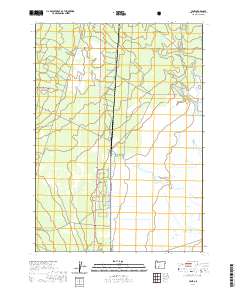
2020 Map of Lenz
USGS Topo · Published 2020About this map
Klamath Marsh National Wildlife Refuge dominates the eastern landscape of this Klamath County region, where the high desert meets extensive wetlands. The settlement of Lenz sits at a transition point between the arid Antelope Desert to the west and the hydrated basin of the marsh. This area is defined by its complex hydrology, with Big Springs feeding into Big Springs Cr, while Scott Cr and Lenz Cr weave through the terrain. The presence of Winema National Forest highlights the managed timberlands that flank the eastern Cascades. Transport and access are marked by Silent Creek, providing a path through the diverse ecosystems of the forest and refuge. The map illustrates a delicate balance of water management and forest preservation in a sparsely populated section of southern Oregon.
Find a feature on this map
15 named features on this map. Tap any name to fly to it.
Don’t see what you’re looking for? This feature index may not catch every label — zoom into the map to look around manually.
Map Details
Editions of this 2020 Lenz Map
This is the sole edition of this map. No revisions or reprints were ever made.
Other maps of this area

1889 · Klamath
USGS Topo · 1:250,000

1894 · Klamath
USGS Topo · 1:250,000

1935 · Chemult
USGS Topo · 1:96,000

1941 · Chemult
USGS Topo · 1:125,000

1955 · Crescent
USGS Topo · 1:250,000

1955 · Klamath Falls
USGS Topo · 1:250,000

1957 · Crescent
USGS Topo · 1:250,000

1957 · Klamath Marsh
USGS Topo · 1:62,500

1957 · Lenz
USGS Topo · 1:62,500

1958 · Crescent
USGS Topo · 1:250,000