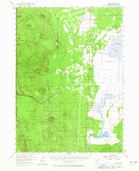
1957 Map of Lenz
USGS Topo · Published 1965About this map
The Klamath Indian Reservation occupies the eastern half of this mid-century survey, where the Southern Pacific railroad runs parallel to the edge of the Klamath Marsh. Small settlements and railroad stops like Lenz, Chinchalo, Fuego, and Kirk are situated along this corridor, providing a glimpse into the transport and ranching infrastructure of the region. To the west, the landscape rises toward the volcanic peaks and timberlands of the Rogue River National Forest and the boundary of Crater Lake National Park (and Vicinity).
Find a feature on this map
41 named features on this map. Tap any name to fly to it.
Don’t see what you’re looking for? This feature index may not catch every label — zoom into the map to look around manually.
Map Details
Editions of this 1957 Lenz Map
2 editions found

Other maps of this area

1889 · Klamath
USGS Topo · 1:250,000

1891 · Ashland
USGS Topo · 1:250,000

1893 · Ashland
USGS Topo · 1:250,000

1894 · Klamath
USGS Topo · 1:250,000

1897 · Ashland
USGS Topo · 1:250,000

1917 · Diamond Lake
USGS Topo · 1:125,000

1935 · Chemult
USGS Topo · 1:96,000

1941 · Chemult
USGS Topo · 1:125,000

1955 · Pelican Butte
USGS Topo · 1:62,500

1955 · Crescent
USGS Topo · 1:250,000