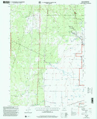
1999 Map of Lenz
USGS Topo · Published 2002About this map
The Antelope Desert landscape in Klamath County is defined by its arid terrain and vital water sources, where natural springs and man-made wells support ranching operations. The Winema National Forest covers much of the western portion, while the eastern edge is marked by the Klamath Marsh National Wildlife Refuge. A network of water features, including Big Springs, Lenz Creek, and numerous flowing wells, reveals how land use was dictated by hydrology in this high-desert environment.
Find a feature on this map
22 named features on this map. Tap any name to fly to it.
Don’t see what you’re looking for? This feature index may not catch every label — zoom into the map to look around manually.
Map Details
Editions of this 1999 Lenz Map
This is the sole edition of this map. No revisions or reprints were ever made.
Other maps of this area

1889 · Klamath
USGS Topo · 1:250,000

1894 · Klamath
USGS Topo · 1:250,000

1935 · Chemult
USGS Topo · 1:96,000

1941 · Chemult
USGS Topo · 1:125,000

1955 · Crescent
USGS Topo · 1:250,000

1955 · Klamath Falls
USGS Topo · 1:250,000

1957 · Crescent
USGS Topo · 1:250,000

1957 · Klamath Marsh
USGS Topo · 1:62,500

1957 · Lenz
USGS Topo · 1:62,500

1958 · Crescent
USGS Topo · 1:250,000