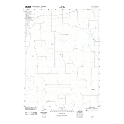
2010 Map of Leon
USGS Topo · Published 2010About this map
The county seat of Leon occupies the northwest corner of this Decatur County landscape, defined by a network of rural routes and the meandering courses of the Weldon River and Little River. A dense concentration of small burial grounds across the countryside provides significant value for genealogical research, including family-named sites such as Chastain Cemetery, Hatfield Cemetery, and Meek Cemetery. The southern reaches of the map show the settlement of Brucewell and the New Salem Cemetery near the winding Kilgore Creek. These features reflect a traditional Iowan agricultural landscape where small rural communities and family landmarks are preserved alongside the modern road system, including Lineville Rd and Quinn Rd. The drainage patterns of Brush Creek and Lick Branch further illustrate the terrain's influence on local settlement and property boundaries.
Find a feature on this map
35 named features on this map. Tap any name to fly to it.
Don’t see what you’re looking for? This feature index may not catch every label — zoom into the map to look around manually.
Map Details
Editions of this 2010 Leon Map
This is the sole edition of this map. No revisions or reprints were ever made.
Other maps of this area

1945 · Lamoni
USGS Topo · 1:62,500

1947 · Lamoni
USGS Topo · 1:62,500

1954 · Centerville
USGS Topo · 1:250,000

1957 · Centerville
USGS Topo · 1:250,000

1958 · Centerville
USGS Topo · 1:250,000

1964 · Woodland
USGS Topo · 1:24,000

1964 · Pleasanton
USGS Topo · 1:24,000

1964 · Leon
USGS Topo · 1:24,000
1964 · Lineville
USGS Topo · 1:24,000

1965 · Garden Grove SW
USGS Topo · 1:24,000