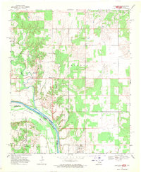
1968 Map of Leon North
USGS Topo · Published 1971About this map
The Red River winds through the borderlands of Oklahoma and Texas in this late-1960s survey, marking a complex fluvial landscape where Illinois Bend creates a dramatic loop in the river’s course. This region is characterized by its rural isolation and the significant role of water drainage, with Red Oak Creek, Mud Creek, and Coffeepot Creek cutting through the terrain. The small community of Leon and the settlement at Rubottom serve as local anchors in an area defined by agricultural grazing and early energy infrastructure, evidenced by several Pipeline routes and numerous Oil Wells. For the genealogist, the map preserves specific burial sites including Courtney Cem and Murrell Cem, providing clear spatial context for families settled along the Love and Montague County line.
Find a feature on this map
25 named features on this map. Tap any name to fly to it.
Don’t see what you’re looking for? This feature index may not catch every label — zoom into the map to look around manually.
Map Details
Editions of this 1968 Leon North Map
2 editions found
Other maps of this area

1901 · Addington
USGS Topo · 1:125,000

1901 · Ardmore
USGS Topo · 1:125,000

1902 · Gainesville
USGS Topo · 1:125,000

1905 · Montague
USGS Topo · 1:125,000

1918 · Ardmore
USGS Topo · 1:125,000

1943 · Gainesville
USGS Topo · 1:125,000

1954 · Sherman
USGS Topo · 1:250,000

1957 · Ardmore
USGS Topo · 1:250,000

1958 · Sherman
USGS Topo · 1:250,000

1963 · Ardmore
USGS Topo · 1:250,000