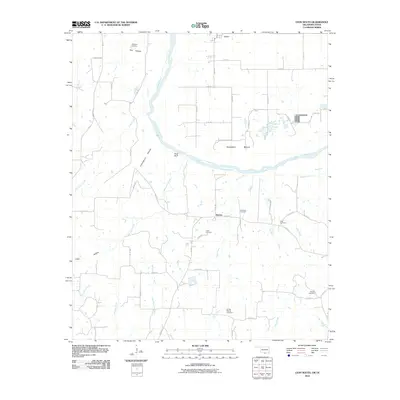
2010 Map of Leon South
USGS Topo · Published 2010About this map
The Red River carves a winding path through this borderland, defining the sharp turn at Saddler Bend and the prominent heights of Rock Bluff. This landscape is marked by the rugged drainage patterns of Mountain Creek and Cedar Creek as they flow toward the river valley. The region is predominantly rural, characterized by small clusters of settlement like Leon in the north and Bulcher further south, connected by a network of county roads and farm-to-market routes like FM 677.
Find a feature on this map
52 named features on this map. Tap any name to fly to it.
Don’t see what you’re looking for? This feature index may not catch every label — zoom into the map to look around manually.
Map Details
Editions of this 2010 Leon South Map
This is the sole edition of this map. No revisions or reprints were ever made.
Other maps of this area

1902 · Gainesville
USGS Topo · 1:125,000

1905 · Montague
USGS Topo · 1:125,000

1943 · Gainesville
USGS Topo · 1:125,000

1954 · Sherman
USGS Topo · 1:250,000

1958 · Sherman
USGS Topo · 1:250,000

1961 · Muenster West
USGS Topo · 1:24,000

1961 · Saint Jo
USGS Topo · 1:24,000

1961 · Muenster East
USGS Topo · 1:24,000
1968 · Bonita
USGS Topo · 1:24,000
1968 · Burneyville
USGS Topo · 1:24,000