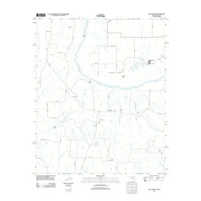
2013 Map of Leon South
USGS Topo · Published 2013About this map
The Red River carves a winding path across this landscape on the border of Oklahoma and Texas, defining the geography around Bulcher. The terrain is marked by distinctive features like Owl Hollow, Rock Bluff, and the sharp turn at Saddler Bend, which illustrate the river's historical impact on the regional layout. This 2013 survey provides essential data for genealogists tracing family histories in the area, as it identifies several small burial grounds scattered across the countryside, including Scanland Cem, Able Cem, Coker Cem, and Williams Cem. The map also captures the intricate network of local drainage, with Mountain Cr, Valley Cr, and Bircham Cr feeding into the main river system. This rural corridor is defined by a grid of county roads that connect these isolated landmarks, preserving the names of early settlements and family landholdings such as Brushy Mound Cem and Roberts Cem.
Find a feature on this map
60 named features on this map. Tap any name to fly to it.
Don’t see what you’re looking for? This feature index may not catch every label — zoom into the map to look around manually.
Map Details
Editions of this 2013 Leon South Map
This is the sole edition of this map. No revisions or reprints were ever made.
Other maps of this area

1902 · Gainesville
USGS Topo · 1:125,000

1905 · Montague
USGS Topo · 1:125,000

1943 · Gainesville
USGS Topo · 1:125,000

1954 · Sherman
USGS Topo · 1:250,000

1958 · Sherman
USGS Topo · 1:250,000

1961 · Muenster West
USGS Topo · 1:24,000

1961 · Saint Jo
USGS Topo · 1:24,000

1961 · Muenster East
USGS Topo · 1:24,000
1968 · Bonita
USGS Topo · 1:24,000
1968 · Burneyville
USGS Topo · 1:24,000