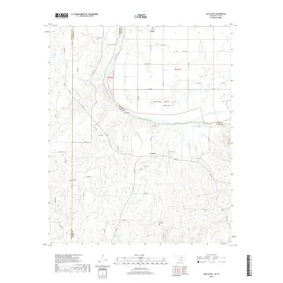
2018 Map of Leon South
USGS Topo · Published 2018About this map
The Red River carves a winding path through this borderland, defining the boundary between Love County, Oklahoma, and Cooke County, Texas. Near the settlement of Leon, the river makes a sharp southern turn at Owl Hollow, eventually forming the distinctive loop of Saddler Bend. The terrain is characterized by numerous small drainage systems like Mountain Cr and Camp Cr that feed into the river valley.
Find a feature on this map
87 named features on this map. Tap any name to fly to it.
Don’t see what you’re looking for? This feature index may not catch every label — zoom into the map to look around manually.
Map Details
Editions of this 2018 Leon South Map
This is the sole edition of this map. No revisions or reprints were ever made.
Other maps of this area

1902 · Gainesville
USGS Topo · 1:125,000

1905 · Montague
USGS Topo · 1:125,000

1943 · Gainesville
USGS Topo · 1:125,000

1954 · Sherman
USGS Topo · 1:250,000

1958 · Sherman
USGS Topo · 1:250,000

1961 · Muenster West
USGS Topo · 1:24,000

1961 · Saint Jo
USGS Topo · 1:24,000

1961 · Muenster East
USGS Topo · 1:24,000
1968 · Bonita
USGS Topo · 1:24,000
1968 · Burneyville
USGS Topo · 1:24,000