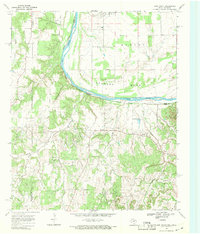
1968 Map of Leon South
USGS Topo · Published 1971About this map
The Red River creates a prominent sweeping curve known as Saddler Bend along the Oklahoma-Texas border in this late 1960s survey. The landscape is defined by the transition from the river lowlands to the elevated terrain of the Burney area and various named hollows such as Owl Hollow and Cottonwood Hollow. This region on the edge of the Red River valley shows a distinct pattern of rural settlement and industry, with the Muenster Oil Field and Bowers Oil Field marking the landscape with various Oil Wells.
Find a feature on this map
30 named features on this map. Tap any name to fly to it.
Don’t see what you’re looking for? This feature index may not catch every label — zoom into the map to look around manually.
Map Details
Editions of this 1968 Leon South Map
This is the sole edition of this map. No revisions or reprints were ever made.
Other maps of this area

1902 · Gainesville
USGS Topo · 1:125,000

1905 · Montague
USGS Topo · 1:125,000

1943 · Gainesville
USGS Topo · 1:125,000

1954 · Sherman
USGS Topo · 1:250,000

1958 · Sherman
USGS Topo · 1:250,000

1961 · Muenster West
USGS Topo · 1:24,000

1961 · Saint Jo
USGS Topo · 1:24,000

1961 · Muenster East
USGS Topo · 1:24,000
1968 · Bonita
USGS Topo · 1:24,000
1968 · Burneyville
USGS Topo · 1:24,000