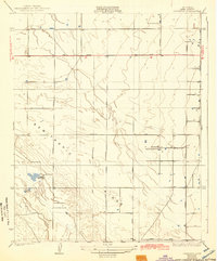
1930 Map of Leonards
USGS Topo · Published 1943About this map
Semitropic Ridge defines the relief of this Kern County landscape, which was surveyed by H.L. McDonald in the late 1920s. This agricultural and recreational terrain shows a transition from structured land tracts to the more irregular drainage of Jerry Slough in the southwest. The presence of specialized social landmarks like the Falcon Fliers Club, Porterville Gun Club, and Sicarte Gun Club suggests a region utilized for field sports and aviation alongside traditional ranching operations. The area is anchored by the small settlement of Leonards and large family holdings such as Rowlee Ranch and Goose Lake Ranch. A network of straight-line section roads, including Famoso Road and Kimberlina Road, organizes the territory, while a dual Power Transmission Line cuts through the center, marking the infrastructure development of the San Joaquin Valley during this era.
Find a feature on this map
17 named features on this map. Tap any name to fly to it.
Don’t see what you’re looking for? This feature index may not catch every label — zoom into the map to look around manually.
Map Details
Editions of this 1930 Leonards Map
3 editions found
Other maps of this area

1910 · Buena Vista Lake
USGS Topo · 1:125,000

1912 · McKittrick
USGS Topo · 1:125,000

1912 · Buena Vista Lake
USGS Topo · 1:125,000

1914 · Lost Hills
USGS Topo · 1:125,000

1927 · Semitropic
USGS Topo · 1:31,680

1930 · Leonards
USGS Topo · 1:31,680

1930 · Hamlin School
USGS Topo · 1:31,680

1930 · Wasco
USGS Topo · 1:31,680

1930 · Pond
USGS Topo · 1:31,680

1930 · Miramonte Ranch
USGS Topo · 1:31,680