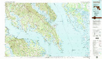
1983 Map of Leonardtown
USGS Topo · Published 1984About this map
St Marys City (Historic) and the deep tidewater estuaries of Southern Maryland anchor this detailed survey of the lower Potomac River and Chesapeake Bay. The map captures a landscape defined by its peninsulas, from the riverfront at Colonial Beach across to the dense wetlands of the Blackwater National Wildlife Refuge on the Eastern Shore. The settlement pattern reflects centuries of maritime dependency, with long-standing communities like Leonardtown and Charlotte Hall serving as inland hubs while significant military and industrial footprints appear at the Patuxent River Naval Air Test Center and the Calvert Cliffs Nuclear Power Plant.
Find a feature on this map
200 named features on this map. Tap any name to fly to it.
Don’t see what you’re looking for? This feature index may not catch every label — zoom into the map to look around manually.
Map Details
Editions of this 1983 Leonardtown Map
2 editions found
Other maps of this area

1889 · Fredericksburg
USGS Topo · 1:125,000

1890 · Mt. Vernon
USGS Topo · 1:125,000

1891 · Mt. Vernon
USGS Topo · 1:125,000

1892 · Leonardtown
USGS Topo · 1:62,500

1892 · Fredericksburg
USGS Topo · 1:125,000

1892 · Drum Point
USGS Topo · 1:62,500

1892 · Prince Frederick
USGS Topo · 1:62,500

1892 · Brandywine
USGS Topo · 1:62,500

1892 · Piney Point
USGS Topo · 1:62,500

1892 · Montross
USGS Topo · 1:62,500
Featured Places
- Lexington Park, MD
- California, Lexington Park
- Chesapeake Ranch Estates, MD
- Wildewood, Lexington Park
- Colonial Beach, VA